Point cloud analysis in a common GIS environment
Bringing 3D Data and GIS Workflows Together
Point clouds don’t exist in isolation. Their real value emerges when they can be analyzed alongside raster- and vector layers. That’s why working within a native GIS environment is a decisive advantage.
With LIS Pro 3D integrated into SAGA GIS, point cloud data becomes a first-class citizen in geospatial workflows - processed, analyzed, and combined seamlessly with other spatial datasets.
From Standalone 3D Data to Spatial Context
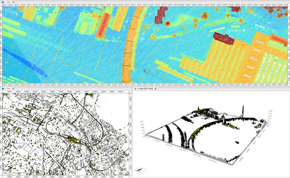
Traditional point cloud tools often operate as isolated systems, disconnected from broader GIS workflows. In contrast, LIS Pro 3D operates directly inside SAGA GIS, enabling immediate access to:
- Raster and vector layers
- Side-by-side visualization of point clouds and other datasets
- Attribute tables and spatial queries
- Digitizing tools
- Tools for terrain analysis, geostatistics and much more
This integration ensures that point cloud analysis is always grounded in spatial context - from terrain models to land-use boundaries.
Analyze Point Clouds Like Any Other GIS Layer
With LIS Pro 3D, point clouds can be:
- Filtered, classified, and segmented
- Queried spatially using polygons or buffers
- Combined with raster layers such as DTMs, orthophotos, or thematic maps
This makes it easy to answer complex questions, such as how vegetation height varies across land-use classes, or how 3D structures relate to terrain, infrastructure, or administrative boundaries.
Seamless Integration with Raster and Vector Data
One of the key strengths of a common GIS environment is interoperability. Point cloud data processed with LIS Pro 3D can be directly combined with:
- Raster datasets (elevation models, indices, heatmaps)
- Vector datasets (buildings, parcels, transects, plots)
This allows workflows where 3D geometry, surface models, and 2D spatial features inform each other - without data duplication or format conversions.
One Environment, Consistent Workflows
By working inside a single GIS platform, analysis becomes more transparent, reproducible, and efficient. Results are easier to validate, share, and integrate into existing GIS pipelines.
Whether you’re working in forestry, urban analysis, or environmental monitoring, combining point clouds with classic GIS data unlocks deeper insights - without leaving your familiar geospatial workspace or interrupting your workflow.