Data Export
From Analysis to Deliverables
After analysis is complete, results must be delivered in formats suitable for clients, stakeholders, or downstream workflows such as CAD or GIS environments. Depending on project requirements, exported deliverables may include enhanced point clouds with updated attributes (e.g. classifications), raster products such as Digital Terrain Models (DTMs), or vector datasets including breaklines, polygon boundaries, meshes, and 3D models.
Seamless Integration into CAD and GIS Software
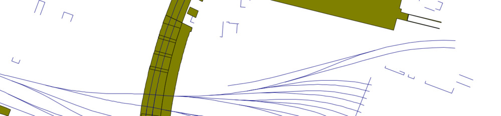
LIS Pro 3D provides flexible and robust export capabilities to ensure seamless data integration. For raster and vector formats, the software leverages the powerful open-source library GDAL, enabling support for a wide range of industry-standard formats. Point clouds can be exported to established formats such as LAS/LAZ, Riegl RDB, or ASCII. CAD-ready geometries - including 3D polylines, polygons, meshes, and 3D models - can be written to formats like AutoCAD DXF and Wavefront OBJ, ensuring compatibility with common design and modeling tools.
Efficient Export from Data Catalogs
For large-area projects, LIS Pro 3D supports direct export from virtual point cloud catalogs. Data can be re-tiled on the fly to match customer-specific tiling schemes, eliminating the need for intermediate processing steps. During the same workflow, gridded products such as DTMs can be generated and exported efficiently.
3D City and Object Models
For semantic 3D city or object models - such as reconstructed buildings or detailed tree models - LIS Pro 3D supports exchange formats like CityGML and CityJSON, enabling integration into urban planning, simulation, and digital twin applications.
Built for Seamless Integration
Together, these export capabilities ensure that analysis results generated with LIS Pro 3D can be seamlessly transferred into downstream environments without loss of structure, precision, or semantic information. Whether delivering enriched point clouds, raster terrain models, CAD-ready geometries, or fully structured 3D city models, the software provides a reliable bridge between data processing and practical application. By supporting established industry standards and scalable export workflows, LIS Pro 3D enables efficient data exchange across disciplines - from surveying and engineering to GIS, urban planning, and digital twin development.
Each of our tutorials includes a dedicated description on how to export data!